I climbed Mount Murud on year 2016, the highest mountain in Sarawak, two years later I manage to fullfill my dream, on climbing Mount Mulu. Mount Mulu its located in Miri Division, Sarawak, and is a UNESCO World Heritage Site. The national park is named after Mount Mulu, the second highest mountain in Sarawak.

9.15am waiting at the Park HQ for our guide and porters. Taking pictures of the surrounding before my hike start. I'm surprise that this park is very well maintain among all the park in Sarawak.
We start our hike not until 10.30am, this is due to some miss communication with our guide. As they are expecting us to get our own lunch pack, and we are expecting them to prepare lunch pack. End up time wasted on getting thing sort up.
However, on the bright side, this gave me more time to take some photos on the Park HQ, as they have made such good effort to decorate the place. For example like these tempered glass with all the writing on the UNESCO details about Mulu National Park.

This is the porters that carry the hiking bag of my team members. I weighted the bags, it starts from 17kg up until 23kg. All of these porters are unsung hero, without them its very difficult for us to reach the summit.


Many big trees inside the national park

Fortunate that able to saw one Amorphophallus Hewittii (bunga keladi / 魔芋花 ) just next to the trail

A rest hut at the junction to Mulu Summit and back to the Park HQ


Discovered an abandon bee hive on the ground, big size.

The water came from the hole of the limestone wall.


12.46pm, Stoped at the tributary of the sungai Melinau Paku (Melinau river) for lunch.

I had fried rice, and an egg. This is the most delicious packed lunch that I ever had.


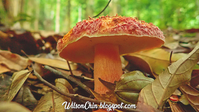
Some very huge mushroom

Camp 1 on the mulu summit trail. Next to it its a stream, with crystal clear running water. The Mulu park also offer a package visitor to camp here, but have to be accompany by a license guide.

These are the porters and cook.

After camp 1, its all uphill. And there is still a long way to go until camp 3, but don't rush it, take your time, enjoy the view, enjoy the sound of nature. And you will get there eventually.


The weather there unpredictable, it rain evey evening during my hike to summit. Its due to the geography formation on the mountain, and the vapor are easily The vapors are easily being cool down and turns back into raindrops. Make sure that all of your item are fully waterproof.


Reach camp 3 at 5.30pm, the elevation of camp 3 is about 1400m ASL. At night the tempreture its about 17'c


My friends are waiting for the porters to arrive, because their dry clothes are all with the porters. Me and Loong did not get porters, we carry our own, so we have dry clothes to change.

All our dinner are prepare by a cook, he is a very kind person. And everyday I saw him wake up early to prepare food for us, feel so grateful for him to cook for us.

Because there is no electricity, no internet, no mobile reception. All we can do after dinner its to chitchat and go to bed early.


Distance: 16km
Max Altitude: 1446m
Min Altitude: 44m
Moving Time: 7hrs
Start Hiking: 10.30am
Reach Camp 3: 5.30pm
Duration: 7 hours
Mulu Summit Exploration Complete Posts
Mount Mulu Summit Exploration | Post 1 of 3
Mount Mulu Summit Exploration | Post 2 of 3
Mount Mulu Summit Exploration | Post 3 of 3
Mulu Summit Exploration Complete Posts
Mount Mulu Summit Exploration | Post 1 of 3
Mount Mulu Summit Exploration | Post 2 of 3
Mount Mulu Summit Exploration | Post 3 of 3
No comments:
Post a Comment