Blog Archive

Camping at Pugu Beach Lundu Kuching

Pugu Beach situated at Lundu, after Pandan beach. Drive all the way up you will see road sign showing where is the beach location. Its a long stretch of beach, which lead all the way to the river mount of Sungai Sebako Besar.

My friends and I decided to visit the place, and stay at the resort hut which we paid RM50 per night.
Pugu Beach is about 7.11km long from bukit Gondol. The day I visited, was a hazy day. Partly due to the heavy burning on our neighboring country Kalimantan.

A panoramic view of the Pugu Beach, the view are very nice if you are at the top of the bukit Gondol. A small hill on the other end of the beach.

Enjoying the time hanging out with my buddies. Long time did not meet up with them, and camping together with them. Hope in future, we can have time to go for adventure together, just like old time.

This is a simple resort hut, they also have a toilet and washroom. But they don't sell food, so we have to bring our own food and water.

Kapit Town Exploration

My first time visit the Kapit town, and also the last town for me to complete to visit all the division in Sarawak. Kapit situated at the center of Sarawak, Borneo. And currently its accessible by boat, and by car, but the road condition are still not in a good shape as the time I write this post in Oct 2018. 
Therefore speed boats are still being use to go to the Kapit town. The earliest one starts at 5.45am from Sibu. 
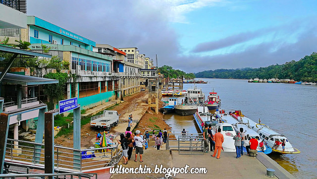
The Rejang river its the life line for the Kapit town, all day to day usage are transport via ship by the Rejang river every single day.
There are many boats in all size dock at the Kapit wharf.
Also several floating gas station can be seen at the Rejang river.
Unloading supply, the lorry needs to go very close to the edge of the river bank. 
Not an easy job, but life still needs to go on.
Me in front of the Kapit district office
Most shop will close after 6pm, so its a bit difficult to find food after 6pm. There is one KFC, not sure what time they close.
Visiting Fort Sylvia. During my stay there, unfortunately it was a public holiday, so its not open. If not I would have visit inside the fort.
Opening Hours:
Tuesday to Sunday 10 - 12 noon & 2 - 5 pm
Closed on Monday and Public Holidays

To prevent further Iban migration upriver in the Rajang River basin, which was creating conflicts with the Orang Ulu, Rajah Charles Brooke built Baleh Fort at Nanga Balleh, the confluence of the Rejang and Baleh rivers between Kanowit and Song in late 1874. 

Rajah Charles Brooke nearly drowned here in 1877 when his boat capsized in the dangerous currents. He abandoned the fort in 1878, and replaced it with a new fort located lower down the river in 1880. The new Kapit Fort was built entirely of ‘belian’ (ironwood) timber with thick walls to withstand attacks.

On 16 November 1924, a peacekeeping ceremony between the Iban, Kayan, Kenyah and Kajang was held here in the presence of Rajah Charles Brooke. In 1925, Kapit Fort was renamed Fort Sylvia after Rani Sylvia Brooke. 

During the 1960s, the fort housed the District Office and the District Court House, and later the Resident’s Office when Kapit Division was formed in 1973.

source: History of Fort Sylvia (Wikipedia)
It even have a high water mark on the wall of the fort, from this can tell that flood issue in the 90s are rather serious. 
I visited several places in Sarawak with house in a man made pond, and the owner will name as name of house follow by the word Danau. I guess the word Danau means house surrounded with water.
Kapit is a small town, but its the biggest division in Sarawak, the district comprises 15,595.6 square kilometres. 

In future I will be coming here frequent as there are many unexplored mountain, one problem its that it is time consuming to reach, because of the poor road condition.  

Mulu Pinnacle View Point at Gunung Api | UNESCO World Heritage Area | Mulu National Park | Post 2 of 2


The Mulu Pinnacle is the most famous spot in the Mulu National Park, due to the sharp looking rock pinnacle on the 1200m ASL viewpoint, its a wonder of nature. 
My friends and I just finished our Mount Mulu Summit climb yesterday, and we continue our adventure again today to the Mulu Pinnacle. This is the life, I get to do the things that I like on day to day basis. I'm so lucky. Adventure never stop!
If your going to hike to the pinnacle soon, I can assure you that this is an easy hike. All you need to do its have a heavy breakfast in the morning, so that you will have enough food to burn into energy.

Well, that's how I felt that morning during my hike, the weather are fine, and birds are singing, my friends are cracking jokes along the way, I don't feel tired at all..well maybe a little bit. 😏
The trail are nicely marked with red paint, but regardless of that, we are not permitted to climb the Pinnacles unaccompanied, must have a licensed guide to bring us there.
limestone rock are everywhere, but because many people had trek here, so the trail are consider stable. Anyway, there are still loose rocks, so better be careful than sorry.
This is at about 900m ASL, the mini pinnacle, we had a quick break here for picture.
Here its about 600m ASL, saw the first batch of hikers left some of their bottle of water here. They did so because after their descent, they will still have water to drink. For me, I bring about 1.5 litter of water. The guide will advice you to bring from 2 - 3 litters of water. 
Here is the first ladder, about 1000m ASL. Its all climbing after this, many vertical rock faces. You will need all 4 limbs to help you get up.
The rope had been bolted nicely on the rock, it looks very stable to be. 
This morning we start at 06.30am, and reached at 10.00am. A total of 3 hours 30 min, 2.4km to the view point at 1200m ASL. 
A panoramic view over the pinnacle
I'm so hungry, this is the packed lunch prepare by my guide. 
The descend its a bit challenging compare to ascend, you need to descent slowly, plan your steps wisely to even the weight so that your knee will not get huge amount of pressure. Remember, protect your knees because there are still many mountain to climb in the future 💪😀 


Things to Bring:
Food
water 2-3 litter
Rain coat

I don't recommend to bring hiking stick, not suitable in this terrain.

Some of the scars and bruises I get on climbing both Mulu Summit, and the Pinnacle
I've got 😁 a certificate issue by the Mulu National Park

From Camp 5 to Pinnacle View Point
Start Time: 06.30am 
End Time: 10.00am 
Total Time:3 hrs 30 min
Distance: 2.4km
Mulu Pinnacle Exploration Complete Posts
Mulu Pinnacle View Point at Gunung Api | Post 1 of 2
Mulu Pinnacle View Point at Gunung Api | Post 2 of 2