Blog Archive

Borneo Highland Resort, Batu Panggah, Penrissen Summit Trail. Post 2 of 2

Continue from the Previous Post, >> Read Post 1 of 2 read here <<
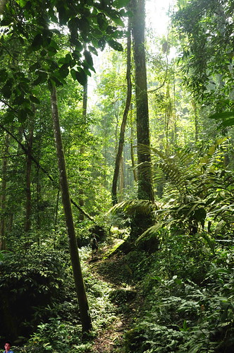
After the rest, we continue on with our journey to the summit. The weather is a big cloudy, and we might encounter rain in the evening when we descend.

DSC_01 - snail
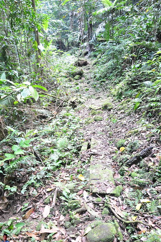
12.22pm. From this point onward its all ascending, and along the way there are a few places which have small stream water flowing down. I found this very tiny snail which I nearly step on it.

DSC_02
12.25pm. And also there are a lot of wild orchids along the way. Sometime we even can find more than 10 different species of orchid on a tree trunk. Good sign, as it shows that the forest on my home land are still rich with flora...must cherish it. So along the way, whenever I saw any plastic bags, or bottle I will take it along with me, and throw it when I reach the resort.

DSC_03 - leech
12.45pm. Leech, live in humid/wet places. And leech is a very fragile animal, so if you ever encounter leech, it means that the place are still in a good condition. There are 4 of us, and one of my friend been bitten by leech at least 10 times. While for me, I keep on checking on my leg, if I found one, I will just pull it away. So far leech bite for today is ZERO ;) but a few time nearly got bitten like this one.

DSC_04 - jelly looking mushroom
12.55pm. Saw a rambutan look alike mushroom. I did not disturb the mushroom, but just took a picture of it.

DSC_05 - mount view
1.04pm. Yeah!!! the summit. We finally reach the summit, well that’s not tough. The student told us that there will be a lot of ladders to climb, but we did not see any ladders. I think they are bluffing. 

This is me enjoyed the view. Nice, I can see the golf court from up here, but not the Kalimantan (Indonesia) border. It must be on the other site. While we’re here, we rest, and ate some food.  And one of my friend got bitten by leech again, oh my... pity him.

DSC_06 - millipede
1.21pm. I saw one millipede, so different between a millipede and a centipedes is that millipedes have paired legs, while centipedes don't. This was told by one of the insect expert from the Borneo Highland tour guide.

DSC_07
1.37pm. Oh, the students are right...the rest stop just now its not the summit. Cause I just saw a signboard saying that the Penrissen summit is strait up :(


We take our time to reach the summit, and along the way my friends stop whenever they hear the sound of birds singing.


DSC_08 - stick looking insect
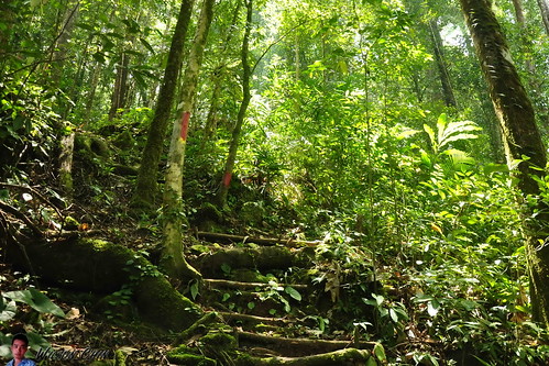
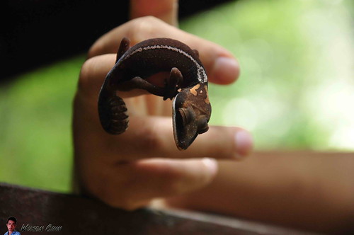
1.55pm. There are so many ladders to climb, the ladder are made from aluminium and this is to avoid corrosion. While I was in the middle of climbing the ladder, I saw this weird looking insect right in front of me. Its body colour are well blend with the green vine in front of me, its a mantis looking creature.

DSC_09- pitcher plant
2.07pm. We reach flat ground, and I can sense that we’re near to the Penrissen summit. Saw this beautiful pitcher plant along the way.

DSC_10
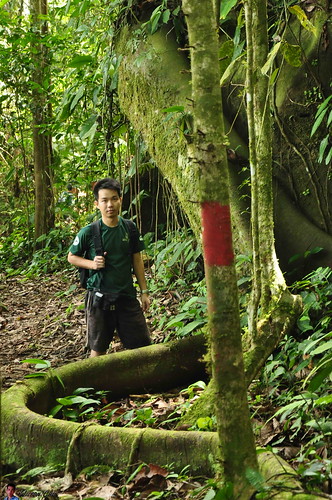
2.13pm. Standing L-R: Leewang, Ho Swee Ping, Front L-R: Wilson Chin (me), and Ong Fu Hong. 

Finally we’re here on the summit. The Penrissen Summit, and from my friend reading we’re on 4360 feet above sea level. And the stone in the middle is the border stone. So the Kalimantan, Indonesia border is the view on the cliff side (where Leewang and I’m at), and Kuching, Sarawak is the one which face to Ho Swee Ping, and Ong Fu Hong near the trail.


From the stone it also marked Republic Indonesia on one side, and Malaysia Sarawak on the other side. So there is no time to waste, we then quickly ascend before it rains.  

Oh ya, about the view up there, it was all covered by fog. Although I took a few pictures, but cannot see anything.
DSC_11
3.03pm. When going down, there are a lot of ladders to climb too, some are very steep. We just take it one steps at a time, and one of my friend even saw a hornbill while on our way down. But he’s so regret that he did not capture the hornbill’s picture.


Then, we saw this adorable tiny squirrel, wondering on the tree trunk. It has a fluffy tails, with white fur on its head.


DSC_12
3.25pm. We reach the ground, this is the golf course hole number 13. My legs feels numb...

DSC_13 - Kalimantan, Sarawak viewpoint
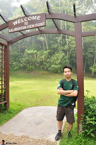
3.46pm. We then need to walk back to our car, where we park at the Kalimantan viewpoint. Remember this morning we skip the view point and head to the trail first, so now lets checkout how is the border looks like. Our neighbour country Kalimantan, Indonesia.

Panorama-borneo-highland-kalimantan-indonesia-view-point-14
So I end my post and my journey to the Borneo Highland Summit trail with this panoramic view of the Kalimantan/Sarawak border view.

More Photos I took in my journey

DSC_0352 - bamboo bridgeDSC_0356DSC_0364DSC_0366 - waterfall and pagodaDSC_0378 - waterfallDSC_0386
DSC_0402DSC_0414 - borneo highland goft courtDSC_0416DSC_0417DSC_0431DSC_0435
DSC_0440DSC_0441DSC_0444DSC_0445DSC_0453DSC_0454
DSC_0461DSC_0465Panorama-big-tree-to-Penrissen-summitDSC_0473DSC_0481 - wild fruitsDSC_0485 - spider web

Borneo Highland Resort, Batu Panggah, Penrissen Summit Trail. Post 1 of 2

My first trip to the Borneo Highland!!! Finally I had the chance to go. I joined 4 of my friends to Borneo Highland...well technically we’re there for the Sarawak Bird Race event, which organise by the Malaysia Nature Society, but we did not join in the event and went on our own to the trail all the way to Batu Panggah (the curse stone), then the Penrissen Summit, and back down again on another trail to reach the golf course hole no.13.


Borneo Highland is the only resort in Kuching, Sarawak which sit on top of the mount at around 1000 meters above sea level. And its surrounded by the thick rainforest with rich flora and fauna. To go up to the resort, they don’t allow personnel car to drive up, as we can only park our car at the foot hill, and the resort will use their own vehicle to pick customer up to the resort (which I don’t like). The Borneo Highland resort is build just right next to the Kalimantan (Indonesia) and Kuching (Sarawak) border. So there is a viewing point where we can view Kalimantan with our naked eyes.
So that morning I woke up at 5.30am, cleanup myself then my friend pick me up at around 6am. We went to 10th Mile, the Padawan town to have kolo noodles for breakfast. Then drive another 45 minutes until we reach the Borneo Highland resort. It was a hazy morning, that’s the first time I went there, so I just sat at the back of my friend’s car, quietly and enjoy the misty morning ride up to the resort.

DSC_0001 - Waterfall on the way up to Borneo Highland Resort
8:00am, on our way up to the resort. We stop by to took some pictures on the waterfall. It was beautiful! There is a pagoda, and stone steps which allows us to walk in to the waterfall. The water are crystal clear, I washed my face with the stream water, cozy!!!

I can hear the sound of the flowing water, the birds singing, and some morning breeze gently blowing to my face.

DSC_0002 - Borneo Highland Resort lobby
8:32am, reached the resort. We then registered ourself (remember we went there for the Bird Race :P ) and then went for 2nd round of breakfast. All the food at the resort are vegetarian. No meat is served here.

DSC_0003 - Morning misty view
08:51am, I went around the resort and took a few pictures. There are quite a numbers of chalet build around the area. Is a perfect place for people who want a quiet place to relax and embrace nature.

DSC_0004 - Kalimantan viewpoint
09:33am, this is the starting point and the distance to Batu Panggah will be around 6600 meter. So for the Kalimantan viewpoint we will skip it first, and start our jungle trekking. Two of my friends are birds watcher, they equipped with their binocular so along the way they can stop and watch birds which live in high altitude.
DSC_0005
10:13am. Look at this guy, he has a big root. *ahem* I mean I saw a tree with huge root. Quickly took a picture with this big fella. Along the way, we just follow the mark (red paint) then we are able to reach the rest stop at Batu Panggah (the curse stone). What’s the story behind the curse stone you ask? well, reach along...
DSC_0006
10:28am. The forest here is are mostly in a rather high altitude, it somehow gave me different feeling than the one that I normally hike in lower ground forest. The trees here are huge, but not as huge as I found in the Matang area rainforest.

DSC_0007
11:07am. There are 4 of us, two walk in front, I’m in the middle and frequently stop to took some picture and video. There is one way behind me also enjoying the forest view.
There are some distance between us, so I just keep on walking, there are a turns which I took that I assume the two in front is going this way... I just keep on walking, not until I notice that the trek become strange. I check my mobile, and there are no reception there.

My friends are nowhere to be found now, and I’m in the middle of the jungle. So I stop and wait for my friend at the back to catch up to me, after waited for 10 minutes, still no sign of anyone. And instinct told me that I should go back, and take the other turn (which will take about 15mins), should I follow my instinct, or should I continue assume that my friends are just in front? If its you, what will you do?

DSC_0008
11.35am. For me, I took the first option by follow my instinct and walk back and took the other turns and went up hill. Just when I start to hike up hill, my mobile rang, and my friends called asked me about my location. I told them that I’m now following the red mark which painted on the trees, they told me that I’m going the correct way, and they are waiting in front for me.
DSC_0009
11.41am. Meet my friend on the rest stop, and this is one of our destination. And this place is caled the Batu Panggah also known as The Curse Stone. Batu = Stone, and Panggah is Head House.
DSC_0010 - Batu Panggah
11:46am. I did some searching over the Internet, and found the following story about this place.

Long ago, there was these two villages of the Iban who enemy each other and forbidden to enter each other territories. They even hunt each other’s so called “Warriors' Head” to proof their power! They named themselves “The Head Hunters”. 
A guy and a girl from both different villages fall in love with each other which is forbidden and not allowed. They was being advice to stop seeing each other but they fail to do so and was found out by the Tuai Rumah (Head of Village).
The Orders are out to hunt them down, dead or alive!!! So they ran away together that day, in the heaviest rain they have ever encountered…
From the blur view through the water drops, they saw a wooden house. They decide to enter as shelter from the heavy thunder storm. That was not just any normal wooden house but the mysterious “Head House”, used to store human’s head (or skull) as a Symbol of Victory. But legend has it that no woman (any female include children) should ever enter or else….
Once they enter, the thunder RAWRRRrr mercilessly and in a blink of second strake the “Head House”! The house as the legend turn itself into stone and block every exit out!The rain slows down…villagers found the house had involved into another medium and they know from it, they entered the sacred house…
No one really sure what is the real whole story for both the lovers but this is the only piece of story passed down.

DSC_0011 - Batu Panggah DSC_0012 - Batu Panggah

Batu Panggah,
the Cursed Stone of the Head House…
Let’s get a closer look at the stone, from the first picture it really looks like a face of a person. By the time I wrote this, I was alone in my reading room and it gives me goosebumps while writing this, its 11.36pm when I wrote this.

DSC_0013 - Cat Eyed Gecko
11.59am. We also meet three youngster camp there for 2 nights already, they’re the students from the University Malaysia Sarawak, currently studying Biology. They are there because of doing research, and one of the students showed us this... the Cat Eyed Gecko. But the one I saw, it has a silver eyes. the scientific name is Aeluroscalabotes Felinus. This is the only species in the region to posses eyelids and to be capable of closing its eyes.

Stay tune for the final post of my Borneo Highland adventure, and check out what else I encounter along my trail to the Penrissen Summit...

-- to be continue --
DSC_0352 - bamboo bridgeDSC_0356DSC_0364DSC_0366 - waterfall and pagodaDSC_0378 - waterfallDSC_0386
DSC_0402DSC_0414 - borneo highland goft courtDSC_0416DSC_0417DSC_0431DSC_0435
DSC_0440DSC_0441DSC_0444DSC_0445DSC_0453DSC_0454
DSC_0461DSC_0465Panorama-big-tree-to-Penrissen-summitDSC_0473DSC_0481 - wild fruitsDSC_0485 - spider web
Trip Report:
Borneo Highland Resort, Batu Panggah, Penrissen Summit Trail. Post 1 of 2
Borneo Highland Resort, Batu Panggah, Penrissen Summit Trail. Post 2 of 2

Rediscovered Kuching, Sarawak, Borneo. The land of the Hornbill.

Gedong at Simunjan, private bridge to oil palm plantation 
Gedong at Simunjan, this bridge belongs to a private sector oil palm plantation company. The river water are muddy, and my friend who worked here before told us that the river use to be very clean, it was around 20 years ago.

The oil palm plantation has polluted the place, and also damage the environment. There is no balance in these days, they want to earn more wealth, but in the same time they need to cut down the tress to plant the palm trees. And the one who suffer will be the people who live nearby, and the  flora and fauna at Gedong, Simunjan. 

gedong - benak (Tidal Bore) 
Gedong - benak (Tidal Bore) The river forms a small wave (watched my video at the end of this post). A very unique scene, the water current are flowing from opposite direction, and when they collides they form wave. 

gunung ampungan, serian 
Gunung Ampungan, at the Serian-Sri Aman highway, 776 meter above sea level. I've been here before, you can read my previous blog by click here.

On top of this mount, there are 3 telecommunication towers which is Celcom, DiGi, and Maxis. It was a cloudy morning, and the higher we go, the thicker the mist. When we reach the summit, we have a short break and ate some dumplings. Can't stay long cause it starts drizzling.... 

kampung tubih, Batuh Ra-ung. Serian -Tebeduk highway 
Kampung Tubih, Batuh Ra-ung. Serian-Tebeduk highway. Look at the rocks formation behind me, and one of the rocks mount has a cave near the top of the summit. What a magnificent scene we have here in Kuching.

kampung senah rayang - padawan outskirt1 
Kampung Senah Rayang, the Padawan outskirt. This is a very remote village, there is situated on the foot hill. When we reach, the mist are covering the forest. The hill are like a mother gently holding her baby (that village) in her arms protecting the baby from danger. 

We stop by for a while, and I talked to a local there, he told me that there is a waterfall just next to this village, and we should go and visit it. I love too, but it starts to rain again, so we have to leave. Pity can't stay long to take picture, but was glad that we do stop by and visit the place.


The video I made during this trip, in this video I will show you more of Kuching which you can't see while in the Town area. Enjoy.

Cheers,
Wilson
The Nature Videographer

Expedition to Batu Kawa, Singai, and Bau - Borneo, Kuching, Sarawak

In today post, I will bring you together with me to an mini expedition. At Kuching, the Batu Kawa - Bau road is the highway that link Sematan/Lundu to the Kuching. Everyday hundred cars passes by, a lot of restaurant/food court are build along the way, and some of them have good business.

That morning, we first went to a places call the Kampung Senibong (Senibong Village). Then all along the way is just small roads that link to each other, its like blood vessel and they connect to each others. That morning a lot of morning mist, and I remember seeing the Matang Mount was covered by clouds on the summit. Its like the mount is wearing a hat, very beautiful scene.

2012_0037

Then, when we drive pass a lake, we saw the mist is slowly, gently, quietly floating on top of the lake. This is a rare scene, and the first time I've ever encounter such beauty of nature. We stop the car, go down and enjoy this gift from nature. I can hear the birds singing, feel the morning breeze, the warm sun gently sprinkle the light on earth. Is like all the plants, and water are still in their bed, just sleeping quietly...

After that, we continue with our journey again, and along the way, we saw there are river with crystal clear water. The sound of the river is too beautiful, with crispy water sound like " grook grook...." (hope I got it right, but just watch my video to really feel it). And some tinny shrimps, and fishes swimming freely in the river.

Then, we continue on with our jouney hope that along the way, we can also encounter the King of fruit Durian (was craving for durian that time).

At first we planted to went to Mount Singai to go to the Church, but the place was too crowded. Then, my fiend bring us to a place where is the main water supply  source for some of the village nearby. Is a waterfall, where the village people install a few water pipe line to harvest the mountain water back to their home.

I'm lucky I have a friend which is have extremely good sense of direction, and he manage to bring us to the place. The place has a few small waterfall, and the water is crystal clear. But since this place is not own by the forestry department, so I can see a lot of littering along our way. This is the work of the local people there.

2012_0041

I'm happy to receive this gift today, and I will continue to discover the rest of the hidden treasure in Kuching, Sarawak. And I know if nearly impossible for the empower authorities to do the preserve work on the forest, so I really hope that all of us can work together to at least make the place clean. When you see plastic bag, coketin in the woods, please help to take the trash out, and throw it in the rubbish bin.

So now, let's watch the video I made on my mini expedition...


Rayan Village Deer Farm, at Jalan Batu Kawa - Bau, Kuching, Sarawak

IMG_0296

The Rayan Village Deer Farm, is hidden at the Singai village, Matang, Kuching. Singai village is named after Mount Singai, the mountain of myths and legends of Togung Kidau, the Flying Warrior, Warrior Princess Mikawel, Togung Kopear, who according to legend could throw objects for miles, and many others.

The farm covers an area of approximately 20 acres and is located at about 40 minutes (drive) distance from Kuching city. To reach the farm, drive along the Batu Kawa/Bau road, a SIGNBOARD points to a right turn at the junction opposite Tondong bazaar, then drive in for 3km where the signboards will guide you to the farm.

The farm is the first deer farm home stay in Kuching, as the owner build a longhouse style chalet for people to spend a night there. Check out my video below on how is the chalet looks like. 

In Sarawak, we really need strong advertisement on our tourism destination. If not because of my friend, myself as a local Kuching people, I will never know such places exist, and what to say for the tourist. Sarawak has a huge potential to become the best tourist sport in Malaysia, all we need is some effort (really put their energy in and do some hard work that deliver) from the respective authorities ;)  


Bamboo Park at Kampung Apar Segong, Borneo, Singai Bau, Kuching

IMG_0299 
The Apar Segong village is at one of the junction at the Batu Kawa - Singai Bau road. In the village, there is a project run by REDEEMS.

Association of Research and Development Movement of Singai Sarawak (REDEEMS) is a community based organization (CBO) for the 12 Kampungs (villages) in Singai area of Bau District in Kuching Division of Sarawak, Malaysia. The 12 kampungs are namely Kpg. Apar, Kpg Segong, Kpg. Barieng, Kpg. Sudoh, Kpg. Atas, Kpg. Tanjong Poting, Kpg. Tanjong Bowang, Kpg. Senibong, Kpg. Daun, Kpg. Bobak Sajong, Kpg. Bobak Sejinjang, and Kpg. Sagah. These kampungs are predominantly inhabited by the Bisingai tribe of the Bidayuh community with an estimated population of not less than 15,000 people.

I visited the Bamboo Park, this park is officially launch by Alfred Jabu Anak Numpang (the Deputy Chief Minister of Sarawak) on 30 Oct 2007. Just right beside the park, the team also build a huge Bidayuh traditional house, its very obvious that they want to turn this place into a tourist destination. The project is still ongoing. For the park, a lot of different spices of bamboo can be found here. Which some are quite pretty.

The place are shaded with tress and bamboo, and windy breeze most of the time. A good place to do jungle trekking. And to learn different types of bamboo, a good place to go for the weekend.


The problem is deforest project is getting serious each and everyday, whenever I've been to a place, I will ask the people there about the habitat surround it, and I always get the same answer. "Tress been cut down, animal been shoot dead" And this may one day be the end of our beautiful rainforest. Please help to preserve our forest.

Mount Matang Maha Mariamman Temple, The Indian Temple at Kuching, Borneo.

IMG_0228wtmk

I joined a new group of friends on my hiking trip in Kuching, today we went to two places. To the matang family park, and hike to the waterfall, then we decided to come to this place. Is called Mount Mike, mount mike is a Christian church on the foot hill, and on top of the mount, there is this India temple called the Maha Mariamman Temple. This is the only place in Kuching where there is an India temple in Kuching.

To go to this place, you need to drive to the direction where the red bridge of Matang is. But when you reach a corner after the Malay mosque, try to lookout on your left, there will be a sign board displayed “Mount Mike”, turn left into the Malay Village, and drive straight in. When you reach the foot hill, there will be a few people there asking money from you to look after your vehicle. We paid RM5 for them.
On the food hill, if you're lucky enough you will discover a few species of pitcher plant. 


The journey to reach the top takes around 40 minutes, the mount is not steep, so is very easy to walk up. On my way up, I saw a group of youngsters from Kuching, they bring their mountain bike over to try out the terrain, and their mountain bike performance. And also some devortise just finish praying, and going down hill.


Before reach to the top, there will be a shrine, and an Indian God in the shrine. Two signboard, on the left is to the Maha Mariamman Temple, and on right up is to the bungalow house of the second white Rajah Charles Brooke. I asked one of the people there, he told me that now there is no more bungalow, but just left a few wooden structure, so is not worth to go over. I thanked him, and continue with my journey.


When reaching the main entrance, another stairway, I been here a few years back, and now the place has become prettier. The temple had change from the old Belian wood temple to a newly build Indian temple. My right knee is aching that time, I rub it with my hand to try ease the pain, but no use. I walk slowly up the stairs, before entering the temple, the priest stop us, and request us to take out our shoes, and wash our legs before entering the temple.


I took out my shoes, washed my hands, legs, face, and hair. And drank the tab water too, cause I finish my water when I'm at Matang waterfall. Then I go in and pray to the Indian God. Also asked for permission to take video inside, and the priest approve. There are also other climbers there, and one of them asked the priest if he knows yoga, and the priest answered yes.


My right knee is killing me, I barely can walk properly. So I keep on rubbing my knee hope the pain will ease a bit. We stayed for 15 minutes, took some pictures, and use another 30 mintues to reach to the foot hill.


I did some google search on the history of this place, and include that history in my video. Please remember to thumb me in my video, and subscribe for more of my nature documentary video, and join me in my journey around Sarawak. 

More Reading:

My first Climb to this place back in year 2006

Cheers,
Wilson
Knee is getting better now...