Blog Archive

Exploration to Saratok Town in Borneo Sarawak with Wilson Chin

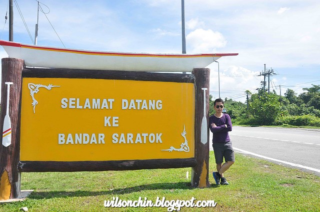
Saratok is a town, in Betong Division, in the island of Borneo, Sarawak. A main annual event in Saratok is the Saratok Regatta or Pesta Air Sungai Krian, a boat-racing event. This event usually takes place during one weekend in July.


Why Saratok been called Saratok?


There are a few version of the stories:
In the book "Legends & History of Sarawak" written by Chang Pat Poh. An old Malay with the Dato title, who wish to visit his relative in the Saratok area. Due to his old age, he always head to the wrong direction, thus people will remind him that "Salah Tok" this is wrong Tok, so slowly the place he went become "Saratok"

Another version believe to be related to the "Salak" tree which can be easily found in Saratok. So people who came here will always said "Salak Tu" where the Tu means here, "here is the Salah trees". So slowly again , people call this place Saratok.

In the book "The Living Legends: Borneo Telling Theirs Tales" by Benedict Sandin. There was this Seru tribe which lead by a warrior called "Segatok". He was being attack by the Iban people, and escape to a small "Munggu" (hill). The hill later name "Munggu Segatok" Segatok wait at the hill. So later then people name the place Segatok, and slowly change to Saratok today.


The Borneo Explorer at the entrance of the Saratok Town

The landmark in the Saratok town, the clock tower in the town center.

The Krian river situated behind the Saratok town, and like every small town in Borneo Sarawak, there must be a Chinese temple.

Since 1888, a lot of Iban people have settlement around the Krian river, and the Sebetan river area, while the Malay settle at Kabong and Sessang, and the Chinese are mostly in the town, Roban and Kabong.

This temple was build on the year 1981, as Chinese likes to build the temple next to the river, as they believe the god will protect them from flood, and they can live harmony and peacefully.

The first few wooden shop house was build by the Chinese (Hokkien dialet) in the earlies 1900s, The Min Syn Chinese school establish since the year 1919, after more Chinese move to Saratok., a great respect to this school, as I believe it had nurture many great people from here.

From the source I gather, I notice that Saratok area have two fort build, the Fort Charles (build in 1878), and Fort Ranee (build in 1888).

I'm not sure sure about the name of this building, but from the source I found, the picture looks like this is the Fort Charles, and the Saratok district use it as the district office last time. And it was build by Mr Maxwell around year 1878 on top of the Sagatok hill.

Once this is a historical building, and now it had become the recreation and service place for Malay community in Seratok (Pusat Rekreasi dan Khidmat Masyarakat Melayu Seratok)

After I step into the building I saw 4 kids running around in the building, there are some garbage around the staircase area, this place are poorly maintain.

A beautiful historical building like this, end up become like an abandon house. It shows how inefficient the authorities are towards the preservation against history. Please make this place a museum, and place all the history information inside there.


The Saratok wet and dry market, selling vegetables at the front, and fish at the back of the market. Not just that, one of the stall even sells antique stuff like kettle, teapot, and plates with Chinese writing.


56 units of the Saratok wooden shop was burn down on the year June, 1970, concrete building shop was build after the fire. In October 1973, a total of 61 concrete building was build on the same spot.

I'm very impress, the town here have library, school, church, temple, district office, and post office. Small town with all the basic facilities, very good structure. Just hope that one day they can make the fort Charles become Fort Charles again, just like the Fort Alice in Sri Aman

Exploration to the Kampung Kiding with Wilson Chin and Friends


10:10am, going to the old Padawan Road to Kampung Kiding. The new road had mudslid since January 2015 this year, and the authorities did not do anything after that.

The old road to Pasawan outskirt is like riding a roller coaster ride. the road is narrow, and a lot of sharp bends.


10:34am, going up to the hill. unbalance road, with mud and rocks a long the way. Steep road to go up, and saw a few village people are also walking up the hill with us, but they are fast.


10:50am, with road condition like this, its impossible for normal vehicle to drive up. No wonder I saw a lot of cars parking at the foot hill. Only trucks, and motorcycle can ride up.


10:56am, finally reach one of the village. The Kakas village (Kampung Kakas), it was really hot that day. I hope my 2 liter of water are enough for me to drink later.


11:05am, reached a waterfall. I felt very tired, the road are too steep for me. My friends and I stop for a rest. 

11.05am, the 4WD struggling very hard to go up the hill.


11.17am, another waterfall, the signboard says "Singapore Waterfall" we stop for a quick rest, and eat some food to refill our energy, and continue on with our journey.


11.42am, this is the last village on the hill. I'm surprise to see there is village here, and felt very terrible for them, cause they have to walk up and down that muddy hill road everyday to connect to the outside world.


12.23pm. I had lost count how many bamboo bridges I cross, then we reached a paddy field. And just look at the view on this field. Its amazing!!!

1:23pm, encounter a big spider blocking our way. My friend got shocked when he notice the web and the spider in the middle. :D

  Lambir National Park in Miri (click to read), I've also lost my way with my brother.
1:35pm, we got a bit off track, cause there are no marking on how to reach the Gareg waterfall. All are base on memories on one of my friend who been here before. We reach to a point where this places has fast moving current with no road, trail ahead, we are going round and round looking for a pathway to go ahead. This reminds me of my hike to


2.05pm, now we are at the ginger garden, and lost our way again :S need to find out where is the route to the waterfall by guessing which path to go.


2:26pm. And finally we are here, after all the exploring. This is adventure!!!


2.40pm, But unfortunately we can't swim here, cause the current are too strong, and the water are mix with dirt. All we can do is just to take a quick lunch, rest, and descent again before its dark.


Gareg Waterfall at the backgroud

5.43pm, Descending now, and very heavy downpour. The road becomes waterfall :P what I worried is sudden mudslide. 


But its very beautiful, look at my homeland Borneo, Sarawak. Its a paradise here, I love my home land so much.

Map and Georaphy location of Kiding Village at Padawan outskirt


Record of One way trip from the foot hill, until the waterfall area


This is the mudslide which damanag the road, and it has been 6 months already, but yet the government or the related authorities are not doing anything. This is very troublesome for the village people there. When can this be fix? I think it might take forever....

Visiting the Pantu Town Borneo Sarawak with Wilson Chin


The Borneo Explorer's record. I'm traveling around Sarawak, and reached a small town called Pantu. 65 kilometres from Sri Aman (Simanggang) division. I'm standing behind the Chinese school in Pantu.

Read more about Sri Aman click link no.1 and link no.2


Every year, the Pantu Festival will held here, it falls before the Gawai (Harvest festive in Borneo, Sarawak) which is around end of May, and before begining of June. Gawai festival in Borneo, Sarawak falls on the 1st & 2nd of June every year. Close to the Benak festival in Sri Aman.

40 mins drive into the Pantu town, you will cross a river the Semulong River, the Semulong River is famous for the Tapah fish. After that if you drive deeper, you can also reach the Bukit Lingga. Can hike to the summit and witness the magnificient view.


This small town have two row of wooden shops, which operate by the Chinese. Most of the shop sells daily groceries and coffee shop.


Each time when I visit small town in Sarawak, its like I'm traveling back in time. And I get to experience the traditional architectural structure of the building, and the way people do trade. People here are so kind and friendly. 

Exploration The village of Murat on the Skrang River Borneo Sarawak

The Skrang River was one of the first areas settled by Iban immigrants in the 16th to 18th centuries. On my exploring trip to Sri Aman, I saw the signboard saying Skrang river safari, so I decided to go in and have a look.

Upon reaching the village, I can see a yellow colored river next to the village, and a lot of cars parked there. Only I notice that it was the harvest festive, and all of the people went back to their longhouse for celebration. I saw two kids riding a bike there. I stop them to ask about what do they have on upstream, the kids told me that there are many traditional Iban longhouses along the Skrang River.


Borneo Explorer was here ;) Wilson Chin