Blog Archive

Ngiraja Cave and Mountain Exploration

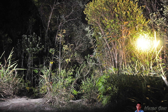
 We are going to a cave which is hidden from public
 Tree vines are all over the place. Water driping from the soil to the ground.
 The entrance are a man made staircase which made from old wood, and nature slowly cover the path back with green
 The handrail are well maintain, as I can see someone just change the rope that tie on the handrail
 Its a steep climb, as I am staring to feel exhausted with all the climbing
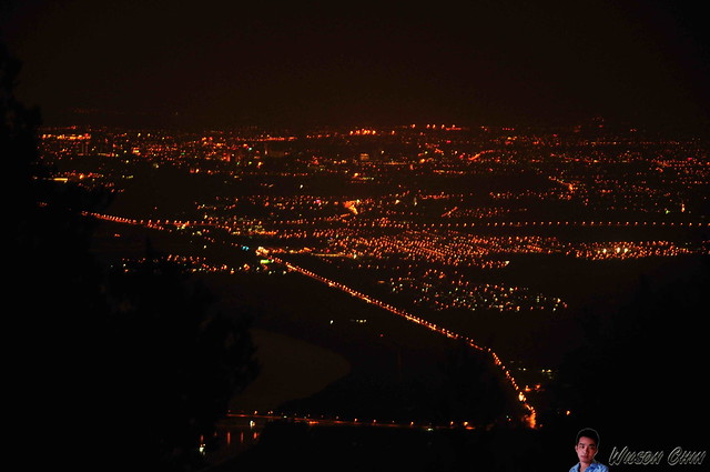
 But the view is worth the climb
 As far as we know, there are two caves which are prohibited  due to its a private place
 So due to respect, we did not explore deep into the cave as we just took some pictures outside.
 The owner of this land also employed a few person to look after this place, which stops us from go any futther. However they are friendly people. 
 #KuchingAdventureTeam caving exploration
 Continue our journey again to the top of the ridge
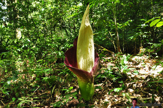
Its another steep climb, and along the way there are lot of exotic orchid which can be found nowhere but here. 
 Breathtaking panoramic view of the Bau area


Singai Mountain Climb Information by Borneo Explorer

Mount Singai at Kuching Sarawak Infographic
Mount Singai Basic Introduction
In Kuching, besides the Mount Santubong, Mount Singai is one of the most prominent mount, where average hikers will reach up to more than 100 people on a normal weekend.

Mount Singai is 550m above sea level, I climbed the mountain countless time. This is a sacred mountain which owns by the Bidayuh people (one of the local Sarawak ethnic group) Bi means people, dayuh means land.

The various Bidayuh tribes, such as the Bisingai, Bijagoi, Bratak, Biperoh, Pinyawa, Bisapug, Bisitang, Biatah, Bibukar and Sadong, had different places in the mountains in the old days as places of refuge for defense purposes. Special traditional rituals and ceremony are being perform on the summit of the mountain.


Now the Catholic Memorial & Pilgrimage Centre is located in the middle of this mountain. For people who like exercise, this is the perfect place to come.

There are stairs built to ease the worshipers heading towards the Catholic Memorial Pilgrimage Centre, after the church is a further trail leading up the mountain to the summit.

How to Get There
Click on the MAP of the Entrance Here

My GPS record to Mount Singai at Kuching, Sarawak
Mount Singai Trail Breakdown
Marker 1:
Base to View Point - 10 min
Height - 191m

Market 2:
Base to Church - 30 mins
Height - 228m

Marker 3:
Base to Twin Trees - 42mins
Height - 302m
The trail is steep here, some may require to use the rope provided

Market 4:
Base to Rest Stop - 1 hour
Height - 394m

Market 5:
Base to Summit - 1h 45 mins
Height - 518m


Flora Found In Mount Singai
One of the rare plat which grows here is the Amorphophallus Hewittii, this flowering plant can be as tall as a grownup person. The plant is also called the titan arum and more commonly, the “corpse plant”. It’s called the corpse plant because of its distinctive, nauseating smell.


Mount Santubong Night Climb Camping

My team and I went to climb the Mount Santubong over the weekend, and we climbed till dawn, and reached the summit with heavy downpour and cold breeze.

Mount Santubong is one of the most prominent mountain in Kuching, its visible from the town on a clear day. With 810m above sea level, its not an easy mount to climb, very challenging, I urge you to try when you next travel to Kuching.

Pitch black along the way, remember to put a touch light when you go hiking, it will come in handy during emergency.
We tough we hear something in the wood, and use our flash light to look around if we can see anything
The Summit View of Mount Santubong, from here we can see the Semariang Town, and Santubong Bridge
F15 the rest hut at the summit. We camp there that night.


5 Things You Can Do At Merarap Hotspring Lawas, Sarawak Borneo

Merarap Hot Spring one of a hidden gem in nortern Sarawak Borneo. Its about 70km away from Lawas town, and only accessible by a 4WD truck.

Here are the 5 things you can do when you visit the Merarap Hot Spring :)

1. Mandi in the hotspring
Hotspring water is piped from a nearby mountain source and dip pools with different water temperature ensure a complete spa experience. Private baths are also available, so there is no way you gonna miss out this one!!! The one behind me consist of cold and hot spring water, so its just nice to dip in the pool..... erm..just beware of leeches :P

2. The Great Trusan River!!!
The Trusan River flows into Brunei Bay, and sits in between the Temburong and Lawas rivers. It's just next to the hotspring lodge. Be aware when you swim here, cause the current are quite strong sometime... but overall its a good place for swim with its cold stream water.

3. Trace the Sources
The pipe connects the water source from the ridge to the lodge's pool, the Merarap owner are bless with this gift of nature. The sources is just a few meter away from where we stay.

4. Food at the Canteen
The Merarap lodge lady owner is really good in cooking, we had buffet dinner with chicken and pork. Look how relax we all are.

5. Merarap Pretty Daughters
After our dinner, all of us look tired right?!! But we are not!!! And all of us still sits at the canteen, where we just want to hangout with the friendly daughters of Merarap... this is how they look like...

Thanks for the pictures Miss Grace, and do say Hi in the comment if you happen to drop by :)


For those of you that missed my earlier post, read here for my Adventure on climbing Mount Murud! Let me know in the comments below will you be friends with them, what are the things you like about hot spring ! 

Enjoy my video

Santubong Mountain Climb Information by Borneo Explorer

Located on the Damai Peninsula, 35km north of the Kuching city. Mount Santubong is surround by hotel resorts, local fishing villages, schools, and the Sarawak Cultural Village. The striking peak is visible from Kuching on most days.

She rise steeply at 810m from sea level, on the bottom of the mountain, numerous streams can be seen, its been stated as a National Park (I wrote this article on August 2016) but I do not see this as a potential sanctuary for wildlife.

The ladder climb which near the summit are poorly maintain, which I foresee it will be extra difficult to summit if this continue. Most of the rest stop indication board had been torn down, one positive sign is there are no litter on the route to summit.

On top of the summit, there is a rest hut. The view as of today (Aug 2016) are mostly covered by trees branches, after the trees grow taller, it will be even more difficult to enjoy the summit view.

Mount Santubong Trail Breakdown

Section 1: Two starting point option
a) Park Entrance to F7 - 2 hours (will passby waterfall)
b) Bukit Putri to F7 - 1 hours (some part with bird eyes view of the coast line)

Section 2: Ladder climb starts at F10
F7 to F12 - 1.5 hours
Here require your upper body strength when climb the ladders

Section 3: Steep climb
F12 to F15 - 0.5 hour

For Camping Enthusiastic
The summit Santubong are suitable for hammock (max 5) and tent camping, its possible to view sunset at summit, and sunset is around 6.30pm. Not possible to view sunrise.

There is a rest hut, maximum can cater two tents (two person in one tent)

No water from F6 onward, please bring at least 2 litters of water for camping. There is a pothole on the summit which contain rainwater, but it also contain urine and stool therefore not suitable to drink.

At night get ready for strong and cold breez, average temperature at 25c