I climbed Mount Murud on year 2016, the highest mountain in Sarawak, two years later I manage to fullfill my dream, on climbing Mount Mulu. Mount Mulu its located in Miri Division, Sarawak, and is a UNESCO World Heritage Site. The national park is named after Mount Mulu, the second highest mountain in Sarawak.
9.15am waiting at the Park HQ for our guide and porters. Taking pictures of the surrounding before my hike start. I'm surprise that this park is very well maintain among all the park in Sarawak.
We start our hike not until 10.30am, this is due to some miss communication with our guide. As they are expecting us to get our own lunch pack, and we are expecting them to prepare lunch pack. End up time wasted on getting thing sort up.
However, on the bright side, this gave me more time to take some photos on the Park HQ, as they have made such good effort to decorate the place. For example like these tempered glass with all the writing on the UNESCO details about Mulu National Park.
This is the porters that carry the hiking bag of my team members. I weighted the bags, it starts from 17kg up until 23kg. All of these porters are unsung hero, without them its very difficult for us to reach the summit.
Many big trees inside the national park
Fortunate that able to saw one Amorphophallus Hewittii (bunga keladi / 魔芋花 ) just next to the trail
A rest hut at the junction to Mulu Summit and back to the Park HQ
Discovered an abandon bee hive on the ground, big size.
The water came from the hole of the limestone wall.
12.46pm, Stoped at the tributary of the sungai Melinau Paku (Melinau river) for lunch.
I had fried rice, and an egg. This is the most delicious packed lunch that I ever had.
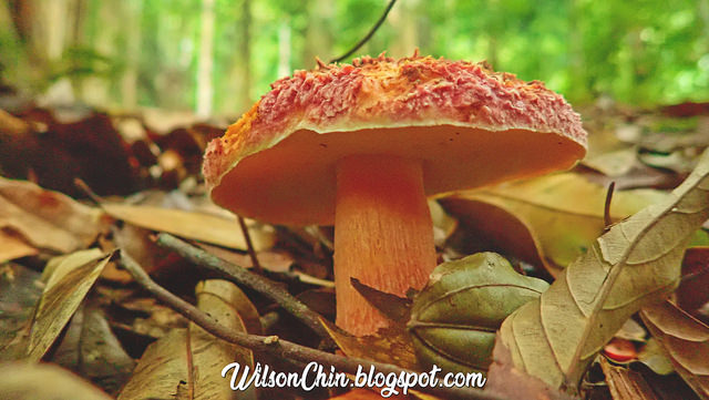
Some very huge mushroom
Camp 1 on the mulu summit trail. Next to it its a stream, with crystal clear running water. The Mulu park also offer a package visitor to camp here, but have to be accompany by a license guide.
These are the porters and cook.
After camp 1, its all uphill. And there is still a long way to go until camp 3, but don't rush it, take your time, enjoy the view, enjoy the sound of nature. And you will get there eventually.
The weather there unpredictable, it rain evey evening during my hike to summit. Its due to the geography formation on the mountain, and the vapor are easily The vapors are easily being cool down and turns back into raindrops. Make sure that all of your item are fully waterproof.
Reach camp 3 at 5.30pm, the elevation of camp 3 is about 1400m ASL. At night the tempreture its about 17'c
My friends are waiting for the porters to arrive, because their dry clothes are all with the porters. Me and Loong did not get porters, we carry our own, so we have dry clothes to change.
All our dinner are prepare by a cook, he is a very kind person. And everyday I saw him wake up early to prepare food for us, feel so grateful for him to cook for us.
Because there is no electricity, no internet, no mobile reception. All we can do after dinner its to chitchat and go to bed early.
4:00am, reach the jungtion of Sarikei Sibu, where here we will be going right to the town of Sibu, we still have about 60km to go until we reach the Sibu Wharf Terminal. I'm so hungry that time, keep on thinking the kampua noodles at Sibu... yummmmmmy.
5:00am, finally reached the Sibu Wharf terminal. We unload our bagpack form the bus, and went to the coffee shop near the wharf for breakfast. I ordered a plate of kampua noodles, and its very tasty.
5.30am, the express boat ticket counter open. Many people are queuing up for ticket. I quickly follow the crowd, and get our ticket. The earliest departure was 5:45am, and I manage to secure our ticket over the counter.
The Rajang river is the longest river in Malaysia at approximately 563 km into Kapit, and then to the South China Sea. We will cruise along the Rajang river to reach the town of Kapit. The boat depart on time, and are fully loaded. First there is a quick stop at the town of Kanowit, I visited this small town here at 2011 (click to read). It is accessible to car. After the all the passenger board the express boat, we star our journey again.
7.50am, the wharf of Song. So far there are road access to Song, but you will need a 4 wheel drive car to reach, so the river still remain the main source of medium to connect to the outside world. Passenger who destination is Song, going out form the boat.
8.15am, went out to catch some fresh air. The scenery along the way was amazing, many mountain range, and surprisingly many big power grid tower. Is this from the Bakum dam? Or Baleh Dam?
8.45am, reached Kapit town. I'm so happy as this is the first time to reach Kapit town, and this trip also completed my journey to visit every division in Sarawak (click to read). Express boat from Sibu to Kapit is 144km via the Rajang river for 3 hours.
8.50am, All the luggage are places on the upper deck, so we have to get our backpack by ourselves. To get there, one have to walk the edge of the boat and climb up to the deck. There are limited space for us to go, so my friend Sui Chin and Ah Loong had volunteer to help get all our backpacks. And Loong seems to be very happy doing it 😆
11.00am Reach the Mujong bridge, and cross the bridge with ease. We are lucky that the bridge had finished constructed at about 3 years ago, else we need to use a boat to cross the Balleh river.
I am very surprise with the well maintain logging road. This 4WD drive will take about 130km for 4 hours to reach Tunoh Mabong area, where we will spend a night at. I remember form one of my many logging road experience, the worse road award goes to the Lawas to Bakelalang road, which takes about 8 hours, Read that story here (click to read)
We stop a a short break from the bumpy car ride, and to take some nice scenery photos
虽然路况还好,但是也是要停一停车,休息拍照一下下。
The peaks of the Hose Mountain. This is just like the 5% if the Hose mount, there are still a vast area of mountain range that can be explore.
这是好山的山脉,这里大概只是山脉的区区 5% 罢了,还有很广阔的山脉能够探险。
2.00pm Behind me is the place that we stay for tonight, its an iban village. Some the villages grows their own paddy. A very vast paddy field, the harvest season just over not long ago. Behind me the local called it Gunung Gajah (Elephant Mount), because the shape looks like an elephant. This is the southern part of the Hose Mountain.
The place that we stayed belongs to an old man, who worked for the government before, and start his home stay business after retired. The name of the house is called Panggau Danu Mabong.
We tour around the Tuoh area, in this village most of them are just old man and young children.
我们就到处走走,这里都是老人与小孩。很少年轻人在村里面。
The Tunoh area is like a basin, surrounded by beautiful mountain range. This place initially the government plant to turn it to become the rice bow of Sarawak, to plant paddy in a large scale, and do export but the project fail.
Borneo Explorer (me) and my little hiking friend Mr Anson.
婆罗洲探险者(我)和我的徒步朋友杨小弟
Evening before dinner, we bath at the Tunoh river. On all my outdoor adventure trip, we always get to bath in the river, this is one of my favorite things to do. The water are crystal clear, and super cold. I like it very much.
Mrs Killau serve us dinner, and the rice that she cooked is from the paddy field. Local rice is always the best, its very very very very very tasty. Just like the one I ate at the Kelabit highland during my Murud trip.
For me, I'm not a big eater. Normally I will eat one plate of rice, but with this local rice, two plates please 🌾🌾🌾
我通常都吃一碗饭,但是有本地白饭,就破例吃两碗饭。
After dinner, its time to do some droning. Want to make use of the soft light during sunset, and get some nice footage for my upcoming video. Sitting next to me is the owner of this place Mr Killau himself, and he is busy taking picture of my drone.
Breathtaking mountain range, the southern part of Hose Mountain. There are so many place I can explore here, I must come back again to explore.
这是好山的南部,看着这些山脉真是漂亮,希望有一天我可以登上最高点,在哪儿露营,享受大自然。
Tomorrow I will explore the Pancur Gelanggang waterfall, Mr Killau told us that the places are all covered with dense vegetation, because no one has visit the place for several years. And told us to be careful when we are there, make sure we do not stand at the base of the waterfall, because rocks will fall down from above, as this happen to them before, very long time ago, he bring his family to bath there, and one of his son'e head being hit by a falling rock. 😓😱