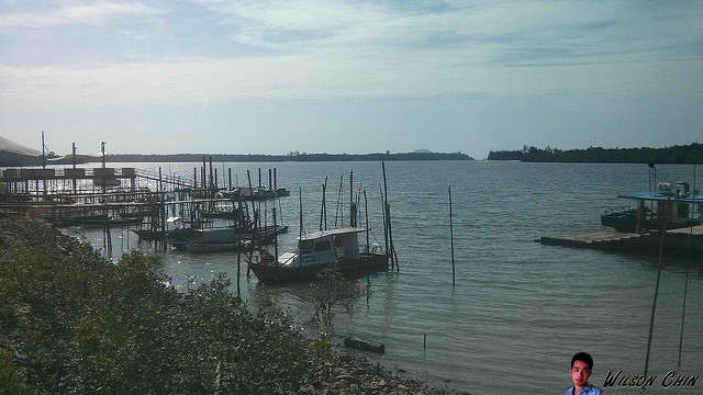
This is the Telaga Air, the Sibu river flows into the South China Sea. It was a hot Saturday, and I'm here to get the contact details on how to get to the Sampadi Island.
This is the Golden Beach, its situated It is located approximately 10 minutes drive away from the Telaga Air fishermen village, and about 35 minutes away drive from Kuching City
The Satang Island can be view from the beach, I went to the Satang island before. Always plan to go back there agian, maybe a camping trip to the island.
A nice place for picnic, or camping.
The water mix with some mud, not very clean. A construction company plans to develop this place, to build villas here and sell to the public. It will be good to be able to own a house near the beach, just that this place is too far away from Kuching city.
Watch my Tanjung Datu Exploration Trip documentary:
Day two at Tanjung Datu
Tanjung Datu may be the smallest of Sarawak’s National Parks, at just under 14 sq km, but it is also one of the most beautiful.
Along the coast line, there are a few sea turtle trails, they dug holes to lay their eggs. The park are running the Turtle Project all year long, and the rangers will collect the egg, record it down, and put in here to make sure that the eggs are safe. After the hatching are born, they will release it back to the sea.
The Kuching Adventure Team, on day two we are going to the Pasir Antu Laut Trail a 2.7KM passes parallel to the beach and through foreshore vegetation, to Tanjung Antu Laut, a picturesque beach where a clear freshwater streams flow around big polished granite boulders into the ocean. The trail then turns inland, and back through mixed dipterocarp forest, crossing several small creeks and ending back at park HQ.
After I reached the beach, was impress on how clean the water is here. Its cleaner than the one we saw at the park HQ.
The sea water are too attractive, and I just take off my shoes and deep my foot in the water.
4 baby sharks swim around the coast, so I'm trying my luck to take their picture, but can't get a good one. If I bring my polarize filter lens I will be able to take clear shoot of the baby shark.
This is the park HQ in the Talang Besar island, as this is a restricted area specially for authorize person only. This island is specially for sea turtle to go lay eggs.
Sea turtle swiming slowly to the Talang Talang Besar Island to lay egg, good luck turtle, wishing you all the best!!!
The Talang Talang Besar Island, this is a national park. But its a restricted area, and its mainly for sea turtle to come here to lay eggs. What the forestry did is good, this can prevent people to come and steal the eggs, and endanger the sea turtle population.
This is the Talang Talang Kecil island, just opposite the Talang Besar island. I heard its also a restricted area, and reserve for sea turtle to lay their eggs.
Watch my Tanjung Datu Exploration Trip documentary:
Day One, Boat Trip to Tanjung Datu, Borneo Sarawak
I organised a trip to the Tanjung Datu National Park over the weekend, located at the south-western tip of Sarawak on the Datu Peninsula, Tanjung Datu is one of Sarawak’s less accessible natural parks, but its relative remoteness is one of its main attractions.
This is the fishing boat that we use to go to Tanjung Datu, the captain is a Malay fisherman staying at Telok Melano.
Reached the national park after 2 hours, I ate medicine before boarding the boat to prevent from getting seasick. The national park does not have wharf, so they use the small boat to send us to shore.
Welcome to Tanjung Datu Park HQ, I register my team information here. the fees have to pay are:
Entrance fees: RM10 per person
Camping fees: RM5 per person
to rent chalet: RM24.40 per night
cooking utensils: RM11 per day
Gas & stove: RM3 per day
Very clean public toilet, and shower place. If you don't have a camping set, you can also rent it here. Before that you will need to call to the National Park to make your booking via phone at +6082-248 088
Belian Trail
The Belian trail is the highest trails among the reset, it require to hike up steep hill. I barely catch my breath, I would say its the hardest to hike among the reset.
On the very top of the trail, its not the Gunung Melano, but its just a rest stop, after that is descent to the foot hill again. Not much view to see up there as all being covered by thick trees.
Visit the viewing poing on our way back to the park HQ, and the viewing area also does not have a clear view of the beach, cause the trees are blocking most of the view. It will be great if the park authorities can do something about this, maybe clear a few trees in front to make the view better.
The water at the beach Crystal Clear!!! this is the first time in I saw such clear water in Sarawak. Very nice to swim :) along the sea shore, we saw a lot of sea turtle trail, they craw to the shore, dig holes and lay their eggs. All the eggs are being collected by the national park to help them breed, after the eggs hatch, they will release the baby turtle back to the sea.


 Visit the viewing poing on our way back to the park HQ, and the viewing area also does not have a clear view of the beach, cause the trees are blocking most of the view. It will be great if the park authorities can do something about this, maybe clear a few trees in front to make the view better.
