Part One
Part Two
Part Three
I’m now at open-air along with my cousin brother Kenny, and his friends waiting for Bus No.6 to take us to the Bako village. This is the first time I visit the Bako National Park, and I’m looking forward to it. When we almost reach the village, it starts to rain. “Rain or Shine” this is the respond given from our group leader when asked about the rain. After our group leader arranges the boat and guide, we then start our journey. We hired a local guide name P.E to company us, so on our way to Bako National Park P.E told us a little bit about Bako National Park.
It named Bako because of the Mangrove trees, in Malays mangroves was called “Bako”. This park was established in 1957, and is the smallest park among the national parks in Malaysia. Along our way, there are a lot of this “Platform” the local people here used it to catches “Bubuk” (shrimps), to produce local food like Balacan (shrimps paste). After the 20 minutes boat ride from Bako village (this is the only route to the Bako Park) we had reach Teluk Asam the head quarter of the Bako Park, and the rain is pouring like hell. On the way to Bako Park, I see the cliffs, and mangrove swamps and I keep on hitting my camera shutter button :) is a fun experience.
We all registered our self at the registration office, and on my way to the office I saw a lot of monkeys running around. These freaking monkeys already get use to human, and they even snatch food, and belonging from visitors so we have to be extra careful. P.E told us to avoid direct eye contact with them, so that they will not attack us. Beside the monkeys, along came this “vacuum cleaner” the Breaded Pig. It had a big nose, the way they eat is similar like a vacuum cleaner sucking in all the dust (they can eat non stop!!!).
After we put our belonging in our hostel, we start our jungle trekking trip. And the good news is the rain had stop. First trails is called the Paku/Lintang trail. On our way, we had encounter little lizard, sting less bees, wired shape mushroom. During my trekking, I experience a sudden transition from one specific forest type to another, from mangrove swamp to cliff vegetation. When I was at the cliff vegetation, P.E told us that this cliff had a lot of ants and where there are ants, there will be Pitcher Plants. P.E, Kenny and his friends, they actually can differentiate the type of the pitcher plants, their scientific name, and the characteristic of the plants, for example like how do the plants hunts, where is the digestion area, what is the cover use for. The most interesting part is P.E actually shows us how to obtain the liquid from a pitcher plant. According to P.E, the liquid can be used to cure eyesight, it can be drink (I’ve try some, it had no smell, no taste), and it also can be use as sun block cream. *cought* Kenny said it taste like sperm, hahaha…
After two and a half hour walk, the time then is 1:00pm, and it was hot like HELL. I don’t have a hat, I don’t have sun block cream, I don’t have sunglass, my water is almost finish and my camera is going on low batt mode. Just when I start to feel like sitting down, in front of me is this cliff edge with this breathtaking scene. Below us is a beach, immediately I change my camera batt, and start to press hard on my camera shutter button. The sun is burning my skin, and I barely open my eyes. After the shoots, we all had a rest on the shade. Our group leader told us that we need to go back to our hostel, and to do that we need to walk back. “WHAT!!!, have to walk back!!!” this is most of our reaction; we need to walk for another two and a half hours. Is there any alternative way to go back? Then P.E said, “Yes, you see there…”
(to be continue in my next post.....)
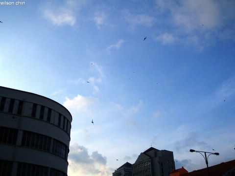
A sunny Saturday morning...
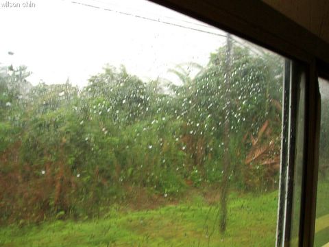
Just when I was about to reach the Bako Village, it starts to rain
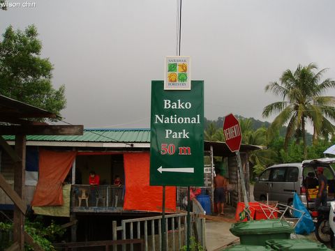
Bako National Park, 50 meter, go left.
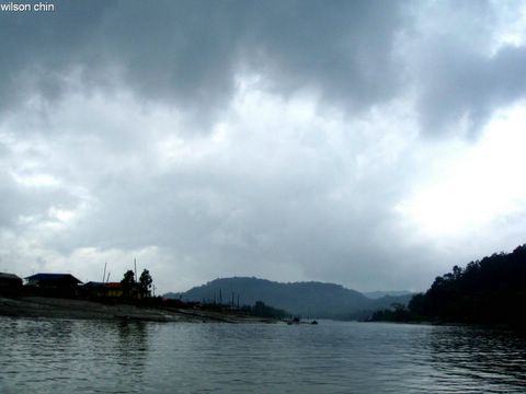
On the left side is the Bako village, most of them are fisherman. Along this river, there are boats everywhere, and they will go to the upstream to catch fish

Our guide P.E told us this platform it is build to catch “Bubuk” shrimps to produce local food like “belacan” (shrimps paste). To build this platform, one needs to obtain a license. The width and the size of the platform is also be determine when apply the license.

Is raining cat-and-dog, and this is when my All-Weather camera comes in handy. So I can keep on pressing the shutter button confidently.
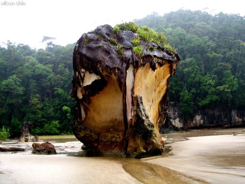
The sea stacks. When we reach is low tide, and is not deep enough for the boat to reach the jetty. So we all have to take off our shoes and walk our way to the entrance of Bako Park. A very fun experience!!!

Welcome to the Bako National Park
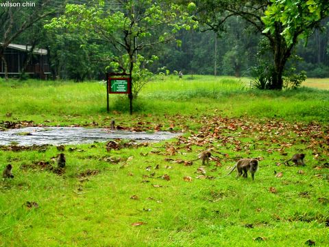
I can saw there are a lot of monkey running around in front of the registration office. They meet people everyday, so they are not afraid of human. One of the monkey even snatch a box of sandwich from a visitor

The Breaded Pig, this big fellow is scare of human, as I saw two local kids chasing it around the office

The one and only canteen at the Park, the food is nice but the price…Next time I come, I should bring some snack

After we unload our luggage at our hostel, we start our jungle tracking

This is my gang, my cousin brother Kenny is the one at the left. Isn’t he handsome and cute :)

This is the mangrove tree, the local Malays called it “Bako”. So this is how Bako Park got its name

According to Kenny, he told me that the mangrove trees roots will grow like a U shape, it grows down into the earth to get a good grip on the earth and grows back out again. So there is a lot of pointing roots surrounding the mangrove tree, this is to let the roots breath. And proboscis monkey eat this mangrove trees leaf.
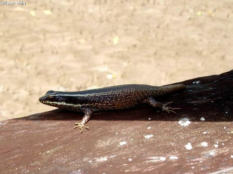
A pity little lizard who lose its tail

Our first trail the Lintang/Paku Trail. Buckle up my dear reader, is a rough ride ahead.

P.E our guild leading the lead, I am very impress with the knowledge that P.E have. He does the explanation on almost every flora and fauna along the trail. And as a local Bako people, he can speak fluent English. And our group leader also possess a lot of knowledge of the flora and fauna of the park as well

Wild berries.

A funny shape mushroom

P.E explaining the characteristic of the pitcher plant
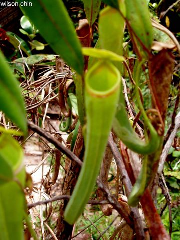
When we start to reach higher ground, I saw more pitcher plants each with different shape, and color

When there is pitcher plants, then there will be ants around. This is one of the ants nest, and this nest is naturally form by this tree especially for the ants. This tree let the ants live inside to help it gain nutrient from the food that the ants take back. So this tree and the ants are good brothers and sister

Wild orchid, and the size is just like a 5 sen penny

The tiniest species of the pitcher plant family

The water of Bako Park is tinted red by the nature. This is due to a mix of mineral ores that are dissolved by the gushing stream. I’ve tasted the water, it taste sour. Just imagine the people here actually drink it
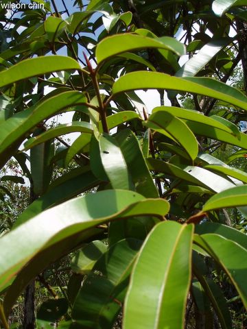
I forgot the name of this plant, according to P.E. There is a group of scientist came to do some research on this plant. The function is to produce an antibiotic for the HIV virus, and it had given a positive effect. They had done experiment on animal by giving it HIV virus, and they used this plant to produce some kind of antibiotic to let the animal eat it. Then the HIV virus had actually disappeared. But until now they are still doing research on it, and I hope it can really cure the HIV infection
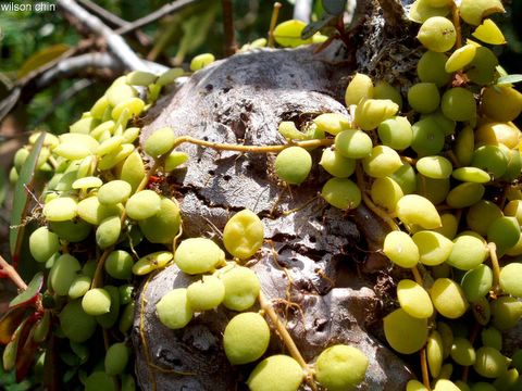
Our group leader knock the tree branch to create vibration, all the ants went out the nets after they sense the vibration.

Another species of the pitcher plant, this pitcher plant had a fat body and with no cover on top of the body
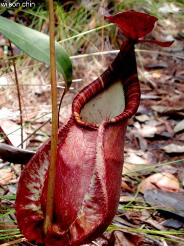
This is the biggest pitcher plant that I’ve seen at Bako Park

A wild flower, which again I can’t remember the name. The size is smaller than a 5 sen penny.

More pitcher plant grows in group
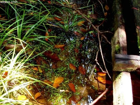
This is something interesting, a bunch of grass which glow. It grow in the water, and the leave glow

This is a very famous leave in Malaysia, this plant is called the “Tongkat Ali” a.k.a Eurycoma Longifolia. P.E asked us to had a bite on the leave, I did and it taste bitter. The leave contains fiber, so is very hard to fold it, or crush it. The root can be produce to become medicine; the root can improve desire and sexual initiation. Hm~~I had bite on the leaf, will it have the same effect as well?
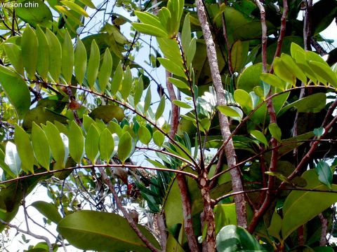
This is how the Tongkat Ali look like, it had a very thin trunk and only grows the leaf on the very top of the trunk. Currently, it is being researched for its possibilities as an anti-cancer supplement

Finally we had reach the very high end of the cliff.

With a breathtaking view below me, on the horizontal sea line lie the Mount Santubong. And if you look carefully there is a small seastack in the middle. That is the famous seastreak which use to symbolize the Bako Park
-------------------------------------------------------
Some of the information was referring from the Inflight magazine of Malaysia Airlines, Going Places on March 2006 issue. Page 22-29 written by Ken Manokaran. Thanks Miracle8 for the magazine :)
It named Bako because of the Mangrove trees, in Malays mangroves was called “Bako”. This park was established in 1957, and is the smallest park among the national parks in Malaysia. Along our way, there are a lot of this “Platform” the local people here used it to catches “Bubuk” (shrimps), to produce local food like Balacan (shrimps paste). After the 20 minutes boat ride from Bako village (this is the only route to the Bako Park) we had reach Teluk Asam the head quarter of the Bako Park, and the rain is pouring like hell. On the way to Bako Park, I see the cliffs, and mangrove swamps and I keep on hitting my camera shutter button :) is a fun experience.
We all registered our self at the registration office, and on my way to the office I saw a lot of monkeys running around. These freaking monkeys already get use to human, and they even snatch food, and belonging from visitors so we have to be extra careful. P.E told us to avoid direct eye contact with them, so that they will not attack us. Beside the monkeys, along came this “vacuum cleaner” the Breaded Pig. It had a big nose, the way they eat is similar like a vacuum cleaner sucking in all the dust (they can eat non stop!!!).
After we put our belonging in our hostel, we start our jungle trekking trip. And the good news is the rain had stop. First trails is called the Paku/Lintang trail. On our way, we had encounter little lizard, sting less bees, wired shape mushroom. During my trekking, I experience a sudden transition from one specific forest type to another, from mangrove swamp to cliff vegetation. When I was at the cliff vegetation, P.E told us that this cliff had a lot of ants and where there are ants, there will be Pitcher Plants. P.E, Kenny and his friends, they actually can differentiate the type of the pitcher plants, their scientific name, and the characteristic of the plants, for example like how do the plants hunts, where is the digestion area, what is the cover use for. The most interesting part is P.E actually shows us how to obtain the liquid from a pitcher plant. According to P.E, the liquid can be used to cure eyesight, it can be drink (I’ve try some, it had no smell, no taste), and it also can be use as sun block cream. *cought* Kenny said it taste like sperm, hahaha…
After two and a half hour walk, the time then is 1:00pm, and it was hot like HELL. I don’t have a hat, I don’t have sun block cream, I don’t have sunglass, my water is almost finish and my camera is going on low batt mode. Just when I start to feel like sitting down, in front of me is this cliff edge with this breathtaking scene. Below us is a beach, immediately I change my camera batt, and start to press hard on my camera shutter button. The sun is burning my skin, and I barely open my eyes. After the shoots, we all had a rest on the shade. Our group leader told us that we need to go back to our hostel, and to do that we need to walk back. “WHAT!!!, have to walk back!!!” this is most of our reaction; we need to walk for another two and a half hours. Is there any alternative way to go back? Then P.E said, “Yes, you see there…”

A sunny Saturday morning...

Just when I was about to reach the Bako Village, it starts to rain

Bako National Park, 50 meter, go left.

On the left side is the Bako village, most of them are fisherman. Along this river, there are boats everywhere, and they will go to the upstream to catch fish

Our guide P.E told us this platform it is build to catch “Bubuk” shrimps to produce local food like “belacan” (shrimps paste). To build this platform, one needs to obtain a license. The width and the size of the platform is also be determine when apply the license.

Is raining cat-and-dog, and this is when my All-Weather camera comes in handy. So I can keep on pressing the shutter button confidently.

The sea stacks. When we reach is low tide, and is not deep enough for the boat to reach the jetty. So we all have to take off our shoes and walk our way to the entrance of Bako Park. A very fun experience!!!

Welcome to the Bako National Park

I can saw there are a lot of monkey running around in front of the registration office. They meet people everyday, so they are not afraid of human. One of the monkey even snatch a box of sandwich from a visitor

The Breaded Pig, this big fellow is scare of human, as I saw two local kids chasing it around the office

The one and only canteen at the Park, the food is nice but the price…Next time I come, I should bring some snack

After we unload our luggage at our hostel, we start our jungle tracking

This is my gang, my cousin brother Kenny is the one at the left. Isn’t he handsome and cute :)

This is the mangrove tree, the local Malays called it “Bako”. So this is how Bako Park got its name

According to Kenny, he told me that the mangrove trees roots will grow like a U shape, it grows down into the earth to get a good grip on the earth and grows back out again. So there is a lot of pointing roots surrounding the mangrove tree, this is to let the roots breath. And proboscis monkey eat this mangrove trees leaf.

A pity little lizard who lose its tail

Our first trail the Lintang/Paku Trail. Buckle up my dear reader, is a rough ride ahead.

P.E our guild leading the lead, I am very impress with the knowledge that P.E have. He does the explanation on almost every flora and fauna along the trail. And as a local Bako people, he can speak fluent English. And our group leader also possess a lot of knowledge of the flora and fauna of the park as well

Wild berries.

A funny shape mushroom

P.E explaining the characteristic of the pitcher plant

When we start to reach higher ground, I saw more pitcher plants each with different shape, and color

When there is pitcher plants, then there will be ants around. This is one of the ants nest, and this nest is naturally form by this tree especially for the ants. This tree let the ants live inside to help it gain nutrient from the food that the ants take back. So this tree and the ants are good brothers and sister

Wild orchid, and the size is just like a 5 sen penny

The tiniest species of the pitcher plant family

The water of Bako Park is tinted red by the nature. This is due to a mix of mineral ores that are dissolved by the gushing stream. I’ve tasted the water, it taste sour. Just imagine the people here actually drink it

I forgot the name of this plant, according to P.E. There is a group of scientist came to do some research on this plant. The function is to produce an antibiotic for the HIV virus, and it had given a positive effect. They had done experiment on animal by giving it HIV virus, and they used this plant to produce some kind of antibiotic to let the animal eat it. Then the HIV virus had actually disappeared. But until now they are still doing research on it, and I hope it can really cure the HIV infection

Our group leader knock the tree branch to create vibration, all the ants went out the nets after they sense the vibration.

Another species of the pitcher plant, this pitcher plant had a fat body and with no cover on top of the body

This is the biggest pitcher plant that I’ve seen at Bako Park

A wild flower, which again I can’t remember the name. The size is smaller than a 5 sen penny.

More pitcher plant grows in group

This is something interesting, a bunch of grass which glow. It grow in the water, and the leave glow

This is a very famous leave in Malaysia, this plant is called the “Tongkat Ali” a.k.a Eurycoma Longifolia. P.E asked us to had a bite on the leave, I did and it taste bitter. The leave contains fiber, so is very hard to fold it, or crush it. The root can be produce to become medicine; the root can improve desire and sexual initiation. Hm~~I had bite on the leaf, will it have the same effect as well?

This is how the Tongkat Ali look like, it had a very thin trunk and only grows the leaf on the very top of the trunk. Currently, it is being researched for its possibilities as an anti-cancer supplement

Finally we had reach the very high end of the cliff.

With a breathtaking view below me, on the horizontal sea line lie the Mount Santubong. And if you look carefully there is a small seastack in the middle. That is the famous seastreak which use to symbolize the Bako Park
-------------------------------------------------------
Some of the information was referring from the Inflight magazine of Malaysia Airlines, Going Places on March 2006 issue. Page 22-29 written by Ken Manokaran. Thanks Miracle8 for the magazine :)
Jay
You are welcome. Lovely pics and nice write-up! Must have been a wonderful experience. We must go there with Fish fish when she comes back. Time to put our cameras to the test, hehe.
But since my camera is not a "semua cuaca" camera, I probably need to wrap it with cling film then. :p
Thanks for sharing an informative and illustrative posting on Bako National Park. The shots on pitcher plant n the other annynomous plant which holds promise as cure for hiv is interesting. Cool, this the first time I got to see a tongkat ali tree.
I only been there once.. and that was way back in 1991...
(15 years ago liao..)
I don't have a camera by then.. cos I was still a secondary school student by then :P
Hope can go back there again in the future :D
Thanks, Bako National Park is a nice place, if you come email me. I can intro u the best travel agent :)
knychai -
hahahaha
miracle8 -
Thank you, ya we can go together. eh, dont worry we can go on a sunny day.
desmond -
:) I'll update tomorrow
walter -
Thanks man, glad u like the photos.
chen -
15 years ago!!! Then did the park change?
Kristopher -
thanks Kris :)
but we hardly took any photos during those days :)
but I still remember we took the shortest route..
I think the 45 minutes route or something like that :D
Ya, my photos cover most of my adventure for that day :)
chen -
thanks for the info Doc :)
Can I ask approx how much you spend for that 3 days 2 nite stay in Bako? Plan to have a visit there too..
Its a nice place, really worth to visit.
Cheers :)
Oic.. thanks a lot for your information. Will surely pay a visit there.. ^^